Matched Content

Showing posts with label Global Positioning System. Show all posts

Sunday, November 19, 2017

TomTom Runner Cardio GPS Watch, Repair Start Switch


TomTom Runner Cardio start switch is not responding. The video below is showing how to repair start switch. A small piece of paper or plastic or rubber band is inserted to allow rocker to press micro switch.


Tuesday, August 9, 2016

My Amazon Kindle Books

My Amazon shop Kindle format epub books. Some of these homemade books are using unused plastic sheet, polystyrene, rubber ban, drinking straw, ice cream stick, etc. to make science toys. Hopefully those books will help to reduce redundant household materials, promote plastic recycle at home, could become precious plastic products, and reduce plastic pollution.

These interesting science toy projects are guaranteed can be done at home. They will make you excited and wake up easily at Sunday morning.

Origami project with plastic sheet to make baking powder submarine


Plastic drinking straws electric boat and submarine


Homemade polystyrene boat or ship and plastic torpedo toys powered by Marangoni effect (different surface tension) 


Do it yourself wooden laser pistol and laser pointer, using laser beam for dry shooting practice.


Marangoni effect (different surface tension) power moves polystyrene toy boat or ship.


Monday, April 15, 2013

Find GPS Destination By Start Point Coordinates, Heading & Distance


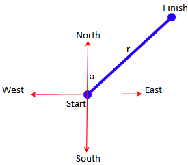
Following the article 'Calculating Heading Angle Or Bearing From GPS coordinates', in this article we discuss on how to calculate the GPS coordinates of the destination point, with start point coordinates, heading, and distance are known. For more details, please see the image below.


‘a’ is the heading angle, with 0 degree points north of the map, 90 degrees is east, 180 degrees is south, 270 degrees for west, and 360 degrees is equal to 0 degree or the north.

‘r’ is the distance from start point to finish point.

If start point is known, then the end point or finish or destination can be calculated.

Download here for Excel document that contains formulas to calculate automatically.

Please note the sequence of latitude-longitude coordinates, not to reverse. Google Maps uses a system of latitude and longitude (y and x), instead of as usual in mathematics longitude and latitude (x and y).

Heading at start and at finish are not always the same, especially for long distances. If we are near the equator, heading at start and at finish point can be almost the same. It is because of our position to the north and south pole are always about the same. For example a flight conducted along the equator toward the east (heading 90 degrees). As long as that aircraft is on the equator and towards the east, whereever its position, the north pole is always on the left, and the south pole is always on the right.

But for flight over the pole, for example the north pole, heading at the beginning of flight is 0 or 360 degrees. When passing over the north pole (90.0), the heading will change to 180 degrees. As flight pass over south pole (-90, 0), the heading will change back to 0 degree. So heading is not constant, although that flight is in a straight line circling the globe.

For example: a flight from Pulkovo International Airport, Saint Petersburg, Russia (59.800278, 30.262500). After taking off from Saint Petersburg, Russia; initial heading toward 0.147 or to the north. Flying to a distance of 6,570.679 km. If those data of starting point, initial heading, and distance are inputted on sheet 'end and midpoint'. Then the end point will be calculate at coordiantes (61.17417, -149.99833) the Ted Stevens Anchorage International Airport, Alaska, United States of America. When approaching Anchorage, heading is changed to 179.844 degrees or South (final heading). Even though the flight is along a straight line, to get the shortest distance.

So to clarify the flight path, it is needed to calculate also the Mid point, ie the point in the middle of a trip, coordinates are (89.309101, 36.265637). Direction of flight at this midpoint is 6,130 degrees.

Example for the region near the south pole: if you are flying from Wellington International Airport, New Zealand (-41.326698, 174.806857). After takeoff the aircraft will head 134. 528 or southeast. Flight distance of 8,569.730 km will at the end point (-41.438512, -73.094015) El Tepual International Airport, Puerto Montt, Los Lagos, Chile. Final heading is 45. 586 degrees before landing. Or heading to the northeast. This flight has midpoint at (-57.631250, -129.216744) near the south pole, the heading at that midpoint is 90 126 degrees or heading east.

Example to the equator: flight from the Supadio airport (-0.14735, 109.402585), Pontianak, West Kalimantan, Indonesia. After take off heading o 91. 920 degrees or to the east. After flying as far 19,173.059 km, will arrive at coordinates (-0.113333, -78.358611) the Mariscal Sucre International Airport, Tababela, Metro Quito, Ecuador. Final heading is 88 078 degrees or to the east.

That equator flight has mid-point at (-1.925201, -164.477443) near Jarvis islands, and heading to 89 983 degrees or to the east. So for flight along the equator, heading almost always constant around 90 degrees.

The picture below is a globe that is stretched into two dimensions or flat, showing that the latitude (blue) is always parallel to the equator (red, latitude 0). The compass direction of the absolute north-south pole (not the earth's magnetic pole) always follows longitude (black).


An airplane from Sydney International Airport (Mascot, New South Wales , Australia) (-33.939976, 151.175437). The aircraft was headed for Cape Town International Airport, Matroosfontein, Cape Town (South Africa) (-33.971490, 18.601967). Seen in the Google maps image below.


Although the two airports have almost the same latitude coordinates of around 34 degrees, the flight does not follow a parallel line with the equator, namely: passing over South Australia, Western Australia, etc.. Because the earth is like a ball, not flat, the closest distance is over Victoria, Tasmania, etc..

Then it will be read on the compass on the aircraft: the initial heading from Sydney flight to Cape Town is 218.173 degrees, the heading at the mid point changes to 321.806 degrees, and at the final point near Cape Tow is 269.966 degrees. Although the aircraft is actually flying straight in the shortest path, following the curvature of the earth.

Earth radius used is 6,378.14 km, which is radius of the earth at the equator. Earth radius value can be adjusted for better accuracy, because the earth is not perfectly round. If using the average value of the earth has 6371 km radius. While the Earth's polar radius is 6,356.7523 km.

Read also calculating land lot area by GPS coordinates.

When using Google Maps, coordinates of calculation result can be copied and paste in the Search box on Google Maps, then press the Search button. Google Maps will show the intended point on the map.

Wednesday, March 20, 2013

Kalkulasi Koordinat GPS Berdasar Data Heading & Jarak


Melanjuti artikel 'Menghitung Sudut Heading Atau Bearing Dari Koordinat GPS', pada artikel ini dibahas mengenai cara menghitung koordinat GPS dari titik tujuan, jika koordinat GPS di titik awal, heading, dan jarak tempuh diketahui. Untuk lebih jelasnya harap lihat gambar di bawah.


a adalah sudut heading, dimana titik 0 derajat adalah arah ke utara peta, 90 derajat adalah arah timur peta, 180 derajat adalah arah selatan peta, 270 derajat adalah arah barat peta, dan 360 derajat sama dengan 0 derajat atau arah utara peta.

r adalah jarak dari start ke finish.

Jika titik awal atau start diketahui, maka titik akhir atau finish dapat dihitung.

Dokumen Excel yang berisi rumus-rumus yang akan menghitung secara otomatis dapat di download di sini.

Mohon diperhatikan bahwa koordinat bujur (longitude) dan lintang (latitude) jangan sampai terbalik. Google Maps menggunakan sistem lintang dan bujur (y dan x), bukan sebagaimana biasanya pada matematika bujur dan lintang (x dan y). Program Excel menggunakan sistem desimal Amerika dimana desimal ditandai dengan titik bukan koma. Sedangkan ribuan ditandai dengan koma, bukan titik.

Heading tidak selalu sama saat start dan saat finish, terutama untuk jarak jauh. Jika kita berada disekitar khatulistiwa atau equator, heading awal dan akhir bisa hampir sama. Hal ini karena posisi kita terhadap kutub utara maupun Selatan selalu hampir sama. Misal suatu penerbangan dilakukan sepanjang garis khatulistiwa ke arah timur (heading 90 derajat). Maka selama pesawat tersebut berada di garis khatulistiwa dan mengarah ke timur, dimanapun posisinya, kutub utara selalu di sebelah kiri, dan kutub Selatan selalu di sebelah kanan pesawat.

Tapi jika perjalanan dilakukan melalui kutub, misalnya kutub utara, saat awal perjalanan heading 0 atau 360 derajat. Ketika melewati titik kutub utara (90,0), maka heading akan berubah menjadi 180 derajat. Walau perjalanan mengikuti garis lurus, tidak berbelok.

Misalnya: penerbangan dari Pulkovo International Airport, Saint Petersburg, Russia (59.800278, 30.262500). Setelah lepas landas dari Saint Petersburg, Rusia; initial heading ke arah 0.147 atau ke utara. Penerbangan ini menempuh jarak 6,570.679 km. Jika data titik awal, initial heading, dan jarak diinput pada lembar ‘end & midpoint’. Maka hasil kalkulasinya adalah penerbangan ini menuju titik (61.17417, -149.99833) yaitu Ted Stevens Anchorage International Airport, Alaska, United States of America. Pada saat akan mendarat maka arah berubah menjadi 179.844 derajat atau ke Selatan (final heading). Walau sebenarnya penerbangan yang dilakukan bergerak di jalur lurus, tidak berbelok agar menempuh jarak tersingkat.

Maka untuk memperjelas jalur yang dilalui, dikalkulasi juga Mid point, yaitu titik di pertengahan perjalanan adalah (89.309101, 36.265637). Arah penerbangan di titik tengah ini adalah 6.130 derajat.

Contoh untuk daerah dekat kutub selatan: jika anda terbang dari Wellington International Airport, Wellington New Zealand (-41.326698, 174.806857). Setelah tinggal landas pesawat akan mengarah ke 134.528 atau sekitar tenggara. Penerbangan akan melintasi jarak 8,569.730 km, dan akan tiba di titik akhir (-41.438512, -73.094015) El Tepual International Airport, Puerto Montt, Los Lagos, Chile. Final heading sebelum mendarat adalah 45.586 derajat. Atau mengarah sekitar timur laut. Titik tengah penerbangan ini adalah di (-57.631250, -129.216744) mendekati kutub selatan, heading pada titik tengah adalah 90.126 derajat atau mengarah ke timur.

Contoh untuk khatulistiwa: Penerbangan dari bandara Supadio (-0.14735, 109.402585), Pontianak, Kalimantan Barat, Indonesia. Setelah lepas landas menuju ke arah 91.920 derajat atau ke timur. Setelah menempuh perjalanan sejauh 19,173.059 km, akan tiba di titik (-0.113333, -78.358611) yaitu Mariscal Sucre International Airport, Tababela, Quito Metro, Ecuador. Final heading adalah 88.078 derajat atau ke timur.

Mid point penerbangan khatulistiwa ini adalah titik (-1.925201, -164.477443) dekat pulau Jarvis, dan heading 89.983 derajat atau ke timur. Jadi untuk jalur sepanjang khatulistiwa, heading hampir selalu konstan sekitar 90 derajat.

Gambar di bawah adalah bola dunia yang dihampar menjadi dua dimensi atau datar, menunjukkan bahwa garis lintang (biru) selalu sejajar dengan garis khatulistiwa (merah, latitude 0). Arah kompas kutub utara-selatan absolut (bukan kutub magnetik bumi) selalu mengikuti garis bujur (hitam) yang tampak melengkung dan tidak tegak lurus terhadap lintang. Pada bola dunia yang bulat, garis bujur selalu tegak lurus terhadap garis lintang.


Sebuah pesawat terbang dari Dubai International Airport, Garhoud, Dubai (United Arab Emirates) (25.253192, 55.365751). Pesawat tersebut menuju Tokyo Haneda Airport, Ōta, Tokyo (Japan) (35.549489, 139.779957). Terlihat pada gambar Google maps di bawah.


Dari khatulistiwa tampak penerbangan tersebut mengikuti garis melengkung, padahal sebenarnya itu adalah garis lurus dengan jarak terpendek yang mengikuti lengkungan bumi.

Maka akan terbaca pada kompas di pesawat terbang: initial heading dari penerbangan Dubai ke Tokyo adalah 58.714 derajat, heading pada mid point berubah menjadi 108.493 derajat, dan pada titik akhir dekat Tokyo adalah 80.258 derajat. Walau secara aktual pesawat tersebut terbang lurus pada jalur terpendek, mengikuti lengkung bola bumi.

Radius bumi yang digunakan adalah 6,378.14 km yaitu radius bumi pada khatulistiwa. Nilai radius bumi dapat disesuaikan agar lebih akurat karena bumi tidak bundar sempurna. Jika menggunakan nilai rata-rata radius bumi yaitu 6371 km. Sedangkan radius pada kutub bumi sebesar 6,356.7523 km.

Baca juga menghitung luas tanah dengan koordinat GPS.

Jika menggunakan Google Maps, maka hasil perhitungan atau titik finish dapat copy lalu paste pada Search box di Google Maps, lalu tekan tombol Search. Google Maps akan menunjukkan titik yang dimaksud pada peta.


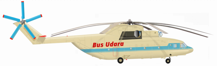
Bus Udara Transportasi Masa Depan saran solusi transportasi Jakarta, Bogor, Depok, Bekasi, Tanggerang, yang cepat, bebas macet dan banjir. Helikopter Mil Mi 26 daya angkut 90 penumpang membuat ongkos ticketnya jadi terjangkau. Estimasi Rp 200.000 Bogor-Jakarta, Rp 100.000 Depok-Jakarta.

Monday, December 10, 2012

Calculating Heading Or Bearing Angle Of GPS Coordinates


Heading is the direction you are walking or driving a vehicle or flying, it is using units of degrees with the north as a point of 0 or 360 degrees. East is 90 degrees, south is 180 degrees, and west as 270 degrees. North may use the magnetic north (compass), but can also use an absolute north (North Pole).


In this attached excel sheet, I use the absolute north as a point of north or 0 degree.


Suppose you are walking from point A to point C, or from starting point to a camp as the above picture, through point B or a bridge at north. Start at point A, you move to the north to point B, or the so-called heading 0 degree, as far as 10 km. Arriving at point B, you turn to the right, or the so-called 90-degrees heading and walk towards point C with 10 km distance. Bearing is the angle of the starting point towards the end of the journey or the destination point, or position of an object from the observer. So a bearing, can be composed of several headings. In the example above, bearing from point A to point C is 45 degrees. Bearing is also called azimuth.

GPS coordinate system used on the Excel sheet is a decimal number, because it is more easily calculated. On ‘conversion’ sheet, there are formulas to change decimal number to sexagesimal (degrees minutes seconds).

Please note the sequence of latitude and longitude coordinate, not to reverse. Google Maps uses a system of latitude and longitude (y and x), instead of as usual in mathematics longitude and latitude (x and y).

Heading when start is not always the same as when finish, especially for long distance. If we are near the equator, heading at the beginning and at the end of travel can be almost the same. It is because of our position on the north and south poles are always about the same. For example a flight conducted along the equator toward the east (heading 90 degrees). As long as the aircraft follows the equator and towards the east, in any position, the north pole is always on the left, and the south pole is always on the right of that aircraft.

Likewise, if we fly along the line of latitude. For example from the south pole to the north pole. During the trip, either at the start or near the destination, north pole position is always in front and the south pole is always in the back. So heading at the start and at the end of flight is almost the same 0 degree.

But if the journey is done over the pole, for example: the north pole, at the beginning of the trip heading 0 or 360 degrees. When passing over the north pole (90,0), the heading will change to 180 degrees.

For example: flights from Pulkovo International Airport, Saint Petersburg, Russia (59.800278, 30.262500) to the Ted Stevens Anchorage International Airport, Alaska, United States of America (61.17417, -149.99833). At Saint Petersburg, Russia after take off; initial heading 0.147 or to the north, when approaching Anchorage just before landing, heading is changed to 179.844 or heading to the south. Even though the flight is following straight line. And the shortest distance between Saint Petersbug to Anchorage is over the north pole.

So to explain the flight path, mid point needs to be calculated, ie the point in the middle of a trip. Saint Petersburg flight towards Anchorage has mid point at (89.309101, 36.265637). Heading at the mid point is 6,130 degrees.

Another example: a flight from Bordeaux Airport, Merignac, France (44.830309, -0.701237) to Toronto Pearson International Airport, Mississauga, Ontario, Canada (43.67768, -79.624958). After takeoff in Bordeaux, flight will be heading to 298.900 degrees. Half way will be at mid point (51.605128, -40.625340) and heading will become 268.540 degrees. Before landing in Toronto, the final heading is 239.258 degrees. So after take off flight heads to approximately north-west, at the mid point heads to the west, while approaching Toronto flight heads to approximately the southwest.

Both cities Bordeaux and Toronto are at nearly the same latitude line, which is about 44 degrees north latitude. But because the shape of the globe, the shortest distance between the two cities does not follow that latitude line. The shortest distance between Bordeaux and Toronto is over the mid point located at 51.6 degrees north latitude, about 8 degrees more to the north of the latitude of Bordeaux and Toronto. If flying from Bordeaux to Toronto follows the line of 44 degrees north latitude, it will always be a constant heading of about 270 degrees. The north pole will always be on the right, and the south pole is always on the left.

The picture below is a globe that is stretched into two dimensions or flat, showing that the latitude (blue) is always parallel to the equator (red, latitude 0). The compass direction of the absolute north-south pole (not the earth's magnetic pole) always follows longitude (black).


An airplane from Seoul Incheon International Airport (South Korea, Republic of Korea) (37.460395, 126.440717). The aircraft was headed for Amsterdam Airport Schiphol (Netherlands) (52.310545, 4.768124). Seen in the Google maps image below.


Although the two airports have almost the same latitude coordinates of around 37-52 degrees, the flight does not follow a parallel line with the equator, namely: passing over China, Kyrgyzstan, Kazakstan, etc.. Because the earth is like a ball, not flat, the closest distance is over China, Mongolia, Rusia, etc..

Then it will be read on the compass on the aircraft: the initial heading from Seoul flight to Amsterdam is 327.710 degrees, the heading at the mid point changes to 227.186 degrees, and at the final point near Amsterdam is 289.147 degrees. Although the aircraft is actually flying straight in the shortest path, following the curvature of the earth.

Earth radius used is 6,378.14 km and it is radius of the earth at the equator. Earth radius number can be adjusted for better accuracy because the earth is not perfectly round. The average value of earth radius is 6371 km. While the Earth's polar radius is 6,356.7523 km.

Read also calculating land lot area by GPS coordinates.

If using Google Maps, then the calculation result can be copied and paste in the Search box on Google Maps, then press the Search button. Google Maps will show the intended point on the map.

For Muslims, this heading formula can be used to calculate and find the qibla direction. By entering the coordinates of your position as the starting point, and the coordinates of the Kaaba (al-Kaʿbah al-Musharrafah, Mecca, Saudi Arabia) as the end point. For example: the qibla direction from Delhi (India) is:

Start: latitude 28.6100, longitude 77.230000 Delhi
End : latitude 21.4225, longitude 39.826167 Kaaba

The formula on the Excel sheet will produce an initial heading  266.614 degrees, or about west direction. This angle is used as the qibla direction from a position in Delhi.


Another example:

Start: latitude 23.5000, longitude 54.500000 Dubai
End : latitude 21.4225, longitude 39.826167 Kaaba

The calculation of the Excel formula will produce an initial heading of 264,154 degrees, or around the west for the qibla direction at Dubai.


Monday, November 19, 2012

Menghitung Sudut Heading Atau Bearing Dari Koordinat GPS

Heading adalah arah anda atau kendaraan berjalan, menggunakan satuan derajat dengan utara sebagai titik 0 atau 360 derajat. Timur adalah 90 derajat, selatan 180 derajat, dan barat sebagai 270 derajat. Titik utara dapat sebagai utara magnetik (kompas), tapi bisa juga menggunakan utara absolut (kutub utara).

Dalam lembar excel terlampir, saya menggunakan titik utara absolut sebagai titik 0 derajat

Lihat gambar dibawah: misalkan anda berjalan dari titik A menuju titik C (camp), melalui titik B (jembatan di utara). Pada saat start di titik A, anda bergerak ke utara, atau disebut heading 0 derajat, menuju titik B sejauh 10 km. Sesampainya di titik B, anda berbelok ke kanan, atau disebut heading 90 derajat dan berjalan menuju titik C sejauh 10 km.

Bearing adalah sudut dari titik awal menuju titik tujuan atau akhir perjalan, atau posisi suatu objek dari pengamat. Jadi dalam suatu bearing, dapat terdiri dari beberapa heading. Pada contoh diatas, bearing dari titik A menuju titik C adalah 45 derajat. Bearing disebut juga sebagai azimuth.


Sistem koordinat GPS yang digunakan pada lembar Excel tersebut adalah angka desimal, karena lebih mudah dikalkulasi. Pada sheet conversion terdapat rumus yang dapat merubah angka desimal menjadi sexagesimal (derajat menit detik). Program Excel menggunakan sistem desimal Amerika dimana desimal ditandai dengan titik bukan koma. Sedangkan ribuan ditandai dengan koma, bukan titik. 

Mohon diperhatikan bahwa koordinat bujur (longitude) dan lintang (latitude) jangan sampai terbalik. Google Maps menggunakan sistem lintang dan bujur (y dan x), bukan sebagaimana biasanya pada matematika bujur dan lintang (x dan y).

Heading di saat start tidak selalu sama dengan di saat finish, terutama untuk jarak jauh. Jika kita berada disekitar khatulistiwa atau equator, heading awal dan akhir bisa hampir sama. Hal ini karena posisi kita terhadap kutub utara maupun Selatan selalu hampir sama. Misal suatu penerbangan dilakukan sepanjang garis khatulistiwa ke arah timur (heading 90 derajat). Maka selama pesawat tersebut berada di garis khatulistiwa dan mengarah ke timur, dimanapun posisinya, kutub utara selalu di sebelah kiri, dan kutub Selatan selalu di sebelah kanan pesawat.

Demikian juga jika kita terbang dari sepanjang garis lintang. Misal dari kutub selatan menuju kutub utara. Selama perjalanan, baik saat start maupun mendekati tujuan, posisi kutub utara selalu di depan dan kutub selatan selalu di belakang. Jadi heading pada saat start dan pada saat mencapai tujuan, selalu hampir sama yaitu heading 0 derajat.

Tapi jika perjalanan dilakukan melalui kutub, misalnya kutub utara, saat awal perjalanan heading 0 atau 360 derajat. Ketika melewati titik kutub utara (90,0), maka heading akan berubah menjadi 180 derajat.

Misalnya: penerbangan dari Pulkovo International Airport, Saint Petersburg, Russia (59.800278, 30.262500) menuju Ted Stevens Anchorage International Airport, Alaska, United States of America (61.17417, -149.99833). Pada saat awal di Saint Petersburg, Rusia; sesudah lepas landas heading ke arah 0.147 atau ke utara, pada saat akan mendarat maka heading berubah menjadi 179.844 atau ke selatan, walau sebenarnya penerbangan yang dilakukan bergerak di jalur lurus, tidak berbelok. Dan jarak terdekat antara Saint Petersbug dengan Anchorage adalah melalui sekitar kutub utara.

Maka untuk memperjelas jalur yang dilalui, dikalkulasi juga mid point, yaitu titik di pertengahan perjalanan. Titik tengah penerbangan Saint Petersburg menuju Anchorage adalah di titik (89.309101, 36.265637). Heading pada mid point adalah 6.130 derajat.

Contoh lainnya: perjalanan udara dari Bordeaux Airport, Merignac, Perancis (44.830309,-0.701237) menuju Toronto Pearson International Airport, Mississauga, Ontario, Canada (43.67768,-79.624958 ). Sesudah tinggal landas di Bordeaux akan mengarah atau heading ke 298.900 derajat. Saat pertengahan perjalanan akan mencapai mid point (51.605128, -40.625340) dan heading berubah menjadi 268.540 derajat. Saat mendekati Toronto, maka final heading adalah 239.258 derajat. Jadi setelah lepas landas penerbangan mengarah ke sekitar barat laut, di mid point mengarah ke barat, saat sebelum mendarat di Toronto pesawat mengarah ke sekitar barat daya.

Kedua kota Bordeaux dan Toronto berada pada garis lintang yang hampir sama, yaitu sekitar lintang utara 44 derajat. Tapi karena bentuk bola bumi, jarak terdekat antara kedua kota tidak mengikuti garis lintang tersebut. Jarak terdekat diantara Bordeaux dan Toronto adalah melalui titik pertengahan atau mid point yang berada pada lintang utara 51.6 derajat, sekitar 8 derajat lebih ke utara dari garis lintang pada kedua kota Bordeaux dan Toronto. Jika penerbangan dari Bordeaux ke Toronto mengikuti garis lintang utara 44 derajat, maka heading akan selalu konstan sekitar 270 derajat, kutub utara akan selalu di sebelah kanan, dan kutub selatan selalu di sebelah kiri.

Gambar di bawah adalah bola dunia yang dihampar menjadi dua dimensi atau datar, menunjukkan bahwa garis lintang (biru) selalu sejajar dengan garis khatulistiwa (merah, latitude 0). Arah kompas kutub utara-selatan absolut (bukan kutub magnetik bumi) selalu mengikuti garis bujur (hitam).


Sebuah pesawat terbang dari King Abdulazis International Airport, Jeddah (Arab Saudi) (21.670443, 39.174643). Pesawat tersebut menuju Los Angeles LAX International Airport, California (Amerika Serikat) (33.941678, -118.408616). Terlihat pada gambar Google maps di bawah.


Walaupun kedua bandara mempunyai koordinat lintang yang hampir sama yaitu sekitar 20-30 derajat, tapi penerbangan tersebut tidak mengikuti garis yang paralel dengan khatulistiwa, yaitu: melalui di atas Libya, Aljeria, Maroko dan menyebrang samudera Atlantik. Karena bumi seperti bola, tidak datar, maka jarak terdekat adalah melalui di atas Islandia, Greenland, dan Kanada.

Maka akan terbaca pada kompas di pesawat terbang: initial heading dari penerbangan Jeddah ke Los Angeles adalah  338.474 derajat, heading pada mid point berubah menjadi  287.716 derajat, dan pada titik akhir dekat Los Angeles adalah  205.755 derajat. Walau secara aktual pesawat tersebut terbang lurus pada jalur terpendek, mengikuti lengkung bola bumi.

Radius bumi yang digunakan adalah 6,378.14 km yaitu radius bumi pada khatulistiwa. Nilai radius bumi dapat disesuaikan agar lebih akurat karena bumi tidak bundar sempurna. Jika menggunakan nilai rata-rata radius bumi yaitu 6371 km. Sedangkan radius pada kutub bumi sebesar 6,356.7523 km.

Baca juga menghitung luas tanah dengan koordinat GPS.

Jika menggunakan Google Maps, maka hasil perhitungan atau titik finish dapat copy lalu paste pada Search box di Google Maps, lalu tekan tombol Search. Google Maps akan menunjukkan titik yang dimaksud pada peta.


Bus Udara Transportasi Masa Depan saran solusi transportasi Jakarta, Bogor, Depok, Bekasi, Tanggerang, yang cepat, bebas macet dan banjir. Helikopter Mil Mi 26 daya angkut 90 penumpang membuat ongkos ticketnya jadi terjangkau. Estimasi Rp 200.000 Bogor-Jakarta, Rp 100.000 Depok-Jakarta.

Bagi umat muslim, rumus heading ini dapat digunakan untuk menghitung dan mengetahui arah kiblat. Dengan cara memasukkan koordinat posisi Anda sebagai titik awal, dan koordinat Ka'bah (al-Kaʿbah al-Musharrafah) sebagai titik akhir. Misalnya: arah kiblat dari Kuala Lumpur (Malaysia) adalah:

Start: latitude  3.13333, longitude 101.70000 Kuala Lumpur
End : latitude  21.4225, longitude 39.826167 Ka'bah

Maka rumus pada lembar Excel akan menghasilkan inital heading  292.539 derajat, atau sekitar arah barat laut. Sudut inilah yang digunakan sebagai arah kiblat dari suatu titik posisi di Kuala Lumpur.


Contoh lain:

Start: latitude 23.50000, longitude 54.500000 Dubai
End : latitude 21.42250, longitude 39.826167 Ka'bah

Kalkulasi rumus Excel akan menghasilkan initial heading 264.154 derajat, atau sekitar arah barat untuk arah kiblat dari Dubai.


Thursday, March 22, 2012

Calculating Land Lot Area with GPS Coordinates


As many readers are looking for a reference to calculate land lot area and perimeter with GPS coordinates data (Global Positioning System), so I create an Excel software specifically for that purpose. Download here.

Simply by writing longitude and latitude data of each vertex of a land lot, then the program will instantly calculate the area and perimeter. To avoid confusing, always use a clockwise direction to input vertex coordinates of the land lot. Counter clockwise direction will get negative result of area calculation.


In the picture below, I calculate area and perimeter of an area around National Monument (Monas, Jakarta). Picture shows GPS coordinates obtained from Google Maps. Please note that Google Maps uses latitude-longitude order.


Shown in the picture above the land lot is an irregular shaped polygon with 8 vertices (octagon). The starting point is the vertex at bottom left, then this point is also used as an end point to form a closed irregular polygon so that the program can calculate it’s area and perimeter. Total 9 GPS coordinates are written, as the starting point and end point at the same vertex. Coordinates are written in yellow cells, and they are sorted in clockwise order. On the right, there is a graph illustrating the measured polygon shape. In this example, octagonal polygon area is 231,339 square meters, and the perimeter is 1782.7 meters.

Read also how Microsoft Excel calculates degrees.

In the attached Excel software workbook, there is also formula to convert GPS data with sexagesimal (degrees minutes seconds) format to become decimal format, then that decimal format will be used to calculate the area and perimeter of a land lot with irregular and regular polygon shaped.

This article is related to previous articles: calculation of polygons and calculate distance with GPS coordinates.

There are two methods for calculation of polygon area, by matrix and by rectangles.

Matrix method is rather difficult to understand but the formula is simpler. And there is an article that explain about polygon perimeter calculation.


If you are looking for a reliable and high quality GPS equipment such as Garmin, TomTom, Magellan, Midland, Rand McNally, including the popular Garmin GPS 60, vehicle GPS, fleet GPS, please check at GPS online shop "Best Sellers in GPS & Navigation Equipment".

Menghitung Luas Tanah dengan Koordinat GPS


Berhubung banyaknya pembaca yang mencari referensi untuk menghitung luas tanah dan kelilingnya dengan data koordinat GPS (Global Positioning System) dan juga koordinat Google Maps, maka saya membuat software Excel khusus untuk keperluan tersebut. Download disini.

Cukup dengan menuliskan data bujur dan lintang dari setiap titik sudut tanah, maka program akan langsung menghitung luas dan kelilingnya. Agar tidak membingungkan, maka selalu gunakan arah jarum jam untuk mengurut titik-titik sudut tanah. Jika kebalikannya maka perhitungan luas akan negatif.

Baca juga cara Excel menghitung sudut (rumus trigonometri).

Pada gambar di bawah, saya mencoba menghitung luas dan keliling suatu area di sekitar Monumen Nasional (Monas, Jakarta). Terlihat koordinat GPS yang didapat dari koordinat Google Maps. Perlu diperhatikan bahwa koordinat Google Maps menggunakan data dengan urutan lintang-bujur.


Terlihat pada gambar di atas bahwa kapling tanah yang diukur berbentuk poligon tak beraturan segi delapan. Titik sudut yang digunakan sebagai starting point adalah titik paling kiri bawah, selanjutnya titik ini juga digunakan sebagai end point sehingga membentuk poligon segi delapan tertutup sehingga program dapat menghitung luas dan kelilingnya. Jadi total koordinat GPS yang diinput berjumlah 9 koordinat, karena starting point dan end point dititik yang sama. Koordinat diinput pada sel berwarna kuning dan diurut searah jarum jam. Di sebelah kanan ada grafik yang menggambarkan bentuk poligon yang diukur. Pada contoh ini luas poligon segi delapan adalah 231.339 meter persegi, dan lingkarannya adalah 1.782,7 meter


Video olahraga menembak pistol laser yang aman dilakukan di mana saja karena tidak ada peluru beterbangan.


Pada Excel software workbook terlampir, juga ada rumus untuk mengkonversi data GPS dengan format sexagesimal (derajat menit detik), menjadi desimal dan selanjutnya digunakan untuk menghitung luas dan keliling tanah yang berbentuk poligon beraturan dan tak beraturan.

Artikel ini berhubungan dengan artikel sebelumnya yaitu: perhitungan luas poligon dan menghitung jarak dengan GPS koordinat. Karena data GPS bisa diambil dari koordinat Google Maps, maka jarak Google Maps dari dua titik tertentu juga bisa dihitung dengan Excel software tersebut.

Perhitungan luas poligon ada dua artikel yang pernah saya tulis yaitu menggunakan metoda matrix dan metoda segiempat.

Metoda matrix agak sulit dipahami tapi rumusnya lebih sederhana. Ada juga artikel yang khusus membahas perhitungan keliling poligon.


Bus Udara Transportasi Masa Depan saran solusi transportasi Jakarta, Bogor, Depok, Bekasi, Tanggerang, yang cepat, bebas macet dan banjir. Helikopter Mil Mi 26 daya angkut 90 penumpang membuat ongkos ticketnya jadi terjangkau. Estimasi Rp 200.000 Bogor-Jakarta, Rp 100.000 Depok-Jakarta.


Monday, October 17, 2011

Calculate the straight distance between two points of GPS coordinates


If you need to calculate the straight line distance between two points of GPS (Global Positioning System, geographic coordinates), where both coordinates are known, but you have no GPS, no computers with satellite maps or internet, cannot online, no cellular phone or handphone with GPS facility, or other tools to measure the straight distance, then the Excel file The following can help you.

Also there is the conversion of sexagesimal into decimal coordinates, and vice versa.

Measurement system used is the GPS coordinates WGS-84 system

Examples of sexagesimal coordinates of Jakarta:
6 ° 10'31 .37 "S, 106 ° 49'37 .56" E

Examples of decimal coordinates of Jakarta:
-6.182010, 106.821100

In decimal coordinates:
Positive number indicates the location at North of equator for latitude,  and at East of Greenwich for longitude. Negative number indicates the location at the South of equator for latitude, and at West of Greenwich for longitude.

It uses radius of the earth 6,378.14 km, that is earth radius at equator. As the earth is not perfectly round, then the earth radius may be changed slightly according to local conditions.

I often use those formulas in the Excel sheets to measure the straight distance on mining projects, measure land lot area, straight distance between two addresses, etc.

For Excel workbook of this calculation, please download here.

Calculation for land lot area and perimeter by GPS coordinates, click here.

Menghitung jarak lurus antara dua titik koordinat GPS


Jika Anda perlu menghitung jarak lurus antara dua titik koordinat GPS (Global Positioning System, geographic coordinates), dimana kedua koordinat sudah diketahui tapi anda tidak punya GPS, tidak ada komputer dengan peta satelit atau internet, tidak bisa online, tidak ada cellular phone atau handphone yang mempunyai fasilitas GPS, ataupun alat lainnya untuk mengukur jarak lurus, maka file Excel berikut dapat membantu anda.

Juga ada konversi dari koordinat sexagesimal menjadi desimal, demikian pula sebaliknya.

Sistem pengukuran yang digunakan adalah GPS coordinates system WGS-84

Contoh koordinat sexagesimal Jakarta:
6°10'31.37"S, 106°49'37.56"E

Contoh koordinat desimal Jakarta:
-6.182010 , 106.821100

Pada koordinat desimal:
Angka positif menandakan lokasi di sebelah Utara ekuator untuk koordinat lintang, dan Timur Greenwich untuk koordinat bujur. Angka negatif menandakan lokasi di sebelah Selatan ekuator untuk koordinat lintang, dan sebelah Barat Greenwich untuk koordinat bujur.

Radius bumi yang digunakan adalah 6,378.14 km, ini adalah radius bumi di sekitar equator atau garis khatulistiwa. Karena radius bumi tidaklah bulat sempurna, maka radius bumi boleh dirubah sedikit sesuai kondisi setempat.


Bus Udara Transportasi Masa Depan saran solusi transportasi Jakarta, Bogor, Depok, Bekasi, Tanggerang, yang cepat, bebas macet dan banjir. Helikopter Mil Mi 26 daya angkut 90 penumpang membuat ongkos ticketnya jadi terjangkau. Estimasi Rp 200.000 Bogor-Jakarta, Rp 100.000 Depok-Jakarta.

Rumus pada lembar Excel tersebut sering saya gunakan untuk mengukur jarak lurus pada proyek tambang, mengukur luas tanah, jarak lurus diantara dua alamat, dan lain-lain.

Untuk dokumen Excel yang mempunyai kalkulasi ini, dapat di download di sini.

Untuk menghitung luas tanah dengan koordinat GPS, klik disini.